Responsable des ventes télématiques et site de publicité autorisé par le ministère de la Justice

Heure du serveur ven. 29/03/2024 heures 14:21 | Europe/Rome

Lands in Trieste

Enchère
n.10843.3

Immeubles > Land Plots

  • Lands in Trieste 1
  • Lands in Trieste 2
  • Lands in Trieste 3
  • Lands in Trieste 4
  • Lands in Trieste 5
  • Description
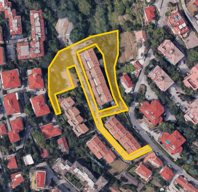
Lands in Trieste, via Bonomea

AUCTION BASED ON RECEIVED OFFER

The lands are registered at Land Registry of City of Trieste at sheet 1:

Parcel 627/2 - Surface 232 sqm - Street
Parcel 719 - Surface 137 sq m - Passage
Parcel 715/4 - Surface 414 sqm - Street
Parcel 627/1 - Surface 52 sq m - Street
Parcel 623 - Surface 523 sqm - Vineyard
Parcel 632/1 - Surface 231 sq.m. - Street
Parcel 632/2 - Surface 336 sq m - Street
Parcel 632/6 - Surface 661 sqm - Street
Parcel 632/7 - Surface 493 sqm - Street
Parcel 632/11 - Surface 100 sqm - Street
Parcel 632/12 - Surface 393 sqm - Garden
Parcel 632/13 - Surface 577 sqm - Street

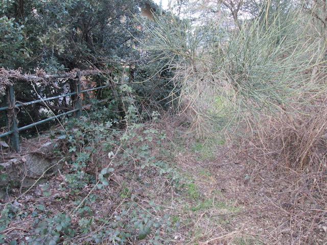
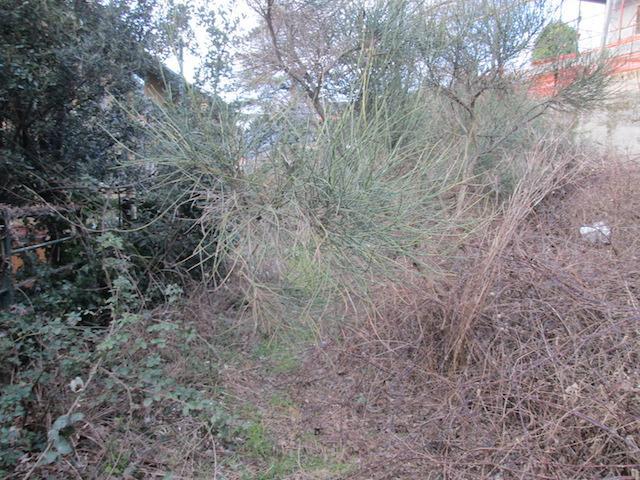
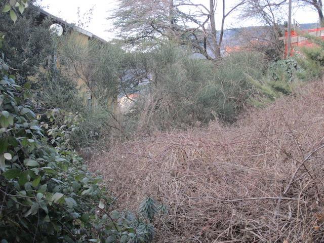
The area in question consists of portions of land of a total of 4,150 square meters partly used as local roads for transit to private properties and car parking and partly preserved in their natural state and covered by spontaneous vegetation consisting of bushes and tall trees.

The new General Town Plan of the Municipality of Trieste (PRGC) approved with D.C. n. 48 dd. 21.12.2015 and became effective with the publication in the BUR n. 18 of 04 May 2016, includes the assets subject to this assessment within the following areas:
• Zone Bo3 - City of objects 3;
• Zone Bg4 - City of vegetable gardens;
• Zone V - Private green.
Furthermore, the Landscape Plan of the Autonomous Region of Friuli Venezia Giulia (PPR), approved by Decree of the President of the Region of 24 April 2018, n. 0111 / Pres and became effective following the publication in the ordinary Supplement no. 25 of 9 May 2018 to the Official Bulletin of the Region n. 19 of 9, includes the same within:
• Landscapes of parks and urban green areas;
• Urban landscapes with medium and low building density.

With the entry into force in 2018 of the new Regional Landscape Plan, referred to above, the current destination of the area is solely for roads.

For further information consult the appraisal and the attached documentation.

Area: 4.149 mq

 Offres:

Lot Suspendu pour

Prix de réserve

Surenchère minimale € 1.000,00

Buyer's Premium see specific terms

Dépôt de Garantie : € 2.500,00

TVA sur le lot 22,00 %le cas échèant

vendu

Demander des informations Demander une vision Conditions Générales Conditions Spécifiques Dati PVP
ID Inserzione1272493
c353bf48-a279-11eb-9e9c-005056b13b25
Procedura
Tipologiagiudiziaria
ID Procedura639518
Tipo Proceduragiudiziaria
ID Tribunale0230910097
ID RitoNUCP
ID RegistroPROCEDURE_CONCORSUALI
TribunaleTribunale di VERONA
RegistroPROCEDURE CONCORSUALI
RitoNUOVO CONCORDATO PREVENTIVO
Num.Procedura13
Anno Procedura2014
Soggetti
  • Soggetto
    TipoSoggetto specializzato alla vendita
    Nome
    CognomeGobid International Auction Group Srl
    Cod.Fisc.GRGNDR67A25H211F
    Emailinfo@gorealbid.it
    Telefono0737782080
    ID Anagrafica2498979
    Soggetto Vendita1
    Soggetto Visita1
Lotto
ID Lotto1160265
Descrizione (IT)Terreno in vendita a Trieste, via Bonomea Vendita telematica sulla piattaforma www.gorealbid.it ASTA 10843
Primo Identificativo1160265
Codice10843
GenereIMMOBILI
CategoriaALTRA CATEGORIA
IndirizzoVia Bonomea
ComuneTrieste
ProvinciaTrieste
RegioneFriuli-Venezia Giulia
NazioneItalia
Beni
  • Bene
    ID Bene1670004
    Descrizione (IT)Il terreno risulta censito al Catasto Terreni del Comune di Trieste al Foglio 1: Particella 627/2 – Superficie 232 mq – Strada; Particella 719 – Superficie 137 mq – Passaggio; Particella 715/4 – Superficie 414 mq – Strada; Particella 627/1 – Superficie 52 mq – Strada; Particella 623 – Superficie 523 mq – Vigna; Particella 632/1 – Superficie 231 mq – Strada; Particella 632/2 – Superficie 336 mq – Strada; Particella 632/6 - Superficie 661 mq – Strada; Particella 632/7 – Superficie 493 mq – Strada; Particella 632/11 – Superficie 100 mq – Strada; Particella 632/12 – Superficie 393 mq – Giardino; Particella 632/13 – Superficie 577 mq - Strada L’area in oggetto consiste in porzioni di terreno di complessivi 4.150 metri quadrati, in parte adibiti a viabilità locale di transito verso proprietà private e parcheggio auto, ed in parte conservate allo stato naturale e coperte da vegetazione spontanea costituita da cespugli e alberi ad alto fusto. Il nuovo Piano Regolatore Generale del Comune di Trieste (PRGC) approvato con D.C. n. 48 dd.21.12.2015 e divenuto vigente con la pubblicazione sul BUR n. 18 del 04 maggio 2016, ricomprende i beni oggetto della presente valutazione all’interno delle seguenti zone: • Zone Bo3 - Città degli oggetti 3; • Zone Bg4 - Città degli orti; • Zone V - Verde privato. Inoltre, il Piano Paesaggistico della Regione Autonoma Friuli Venezia Giulia (PPR), approvato con Decreto del Presidente della Regione del 24 aprile 2018, n. 0111/Pres e divenuto vigente a seguito della pubblicazione sul Supplemento ordinario n. 25 del 9 maggio 2018 al Bollettino Ufficiale della Regione n. 19 del 9, ricomprende gli stessi all’interno dei: • Paesaggi dei parchi ed aree verdi urbane; • Paesaggi urbani a media e bassa densità edilizia. Con l'entrata in vigore nel 2018 del nuovo Piano Paesaggistico Regionale, di cui sopra, l'attuale destinazione dell'area è unicamente a strade.
    Primo Identificativo1670004
    TipologiaALTRA CATEGORIA
    CategoriaTERRENO
    Indirizzovia Bonomea
    ComuneTrieste
    ProvinciaTrieste
    RegioneFriuli-Venezia Giulia
    NazioneItalia
    Bene Immobile
    • Dati catastali
      Foglio/
      Particella/
    Tipo DenunciaProtocollo
Dati Vendita
Data e oraven. 28 mai 2021 heures 16:002021-05-28T16:00:00
TipologiaCOMPETITIVA
ModalitàPRESSO IL VENDITORE
Indirizzovendita telematica sulla piattaforma www.gorealbid.it
CAP20148
ComuneMilano
ProvinciaMilano
RegioneLombardia
NazioneItalia
Prezzo base25.000,00
Offerta Minima25.000,00
Rialzo Minimo1.000,00
Termine Presentazione Offerteven. 28 mai 2021 heures 16:002021-05-28T16:00:00
Pagamento Contributo
Spesa Prenotata Debito
Contributo Non DovutoNo
Siti
  • Sito
    ID22
    Tipologiasito pubblicita
    Nominativohttps://www.gorealbid.it/
    Indirizzo URLhttps://www.gorealbid.it/
Data pubblicazione21/04/20212021-04-21

Lots liés

Lands in Gazzo Veronese (VR) - LOT 2

Immeubles

Lands in Gazzo Veronese (VR) - LOT 2

Enchère 21597.2

Lands in Gazzo Veronese (VR), Locality San Pietro in Valle, Via Piazza - LOT 2

The lands are registered at Land Registry of City of Gazzo Veronese at sheet 34:

Parcel 103 - Arable land - Surface area 2,030 m2 - R.D. €19.40 - R.A. €9.96
Parcel 197 - Arable land - Surface area 3,864 sqm - R.D. € 55.79 - R.A. € 27.94

Almost trapezoidal area reachable from the municipal road Via Piazza, composed of a plot of undeveloped land without fences, with a total surface area of approximately 5,894.00 sqm, entirely falling in the "B1 Speciale" area.
The area in question, cultivated with arable land, appears to have a difference in height compared to the road level, as well as having no primary or secondary urbanization work.

For further information consult the appraisal and the attached documentation.

During each sales experiment it will be possible to submit, using specific forms, offers reduced by up to 25% of the starting value. These offers will be submitted to the Procedure Bodies and, in case of acceptance, the highest offer will become the basis for a subsequent sales experiment.
For the formulation of these offers, any interested parties are required to send a request to the pec address gobidreal@pec.it to find out how to present them and receive the relative offer form.

Sale not subject to VAT
Fiche du Lot
65.000,00

Gazzo Veronese (VR)

Building land in Vallarsa (TN) - LOT 5

Immeubles

Building land in Vallarsa (TN) - LOT 5

Enchère 21953.5

Building land in Vallarsa (TN), Località Anghebeni - LOT 5

The building is registered at the City of Vallarsa:
- Real estate registry: CC 413 parcel 1500/4 sheet 1 category C/2, Class 1, Consistency 6 m2, surface 28 m2, R.C. €8.68; Property 1/4
- Land registry:
- CC 413, Type E, parcel 1500/4, land register number CC 2330, Cultivation Building area, surface area 219 m2 - Property 1/4
- CC 413, Type E, parcel 1500/2, land register number CC 2329, Cultivation Building area, surface area 3,012 m2
- CC 413, Type E, parcel 1500/3, land register number CC 2329, Cultivation Building area, surface area 1,017 m2
- CC 413, Type F, parcel 14264, land register number CC 2329, Unproductive Crops, surface area 750 m2

The properties in question are partially configured as an "access road" and a building lot. The cadastral maps that make up the "access road" are subject to the following easement:
- On 09/12/2003 - G.N. 5149/1 INTRODUCTION OF THE RIGHT OF SERVITUDE step on foot and with mechanical means, charged to P.E. 1500/3 and P.F. 14264 in favor of pdf 1500/5, pdf 1500/6 and pdf 14263; deed d.d. 11/18/2003, 2012 – Report 5513/2
The cadastral maps subject to easement rights are also used without any rights as vehicle parking and open-air storage, the cadastral map which constitutes the building lot is not used improperly, it is therefore free, the borders are clearly identifiable to the North and South, the presence of fences, and less identifiable to the East and West as there are no physical references.
The land previously defined as an "access road" has a rectangular shape, a flat topography, is partially asphalted and there is the presence of a building regularly registered in a state of abandonment and disinterest.

The cost of vacating the property will be borne by the successful tenderer.

For further information consult the appraisal and the attached documentation.
It is also possible to request further documentation at e-mail pec adress gobidreal@pec.it
Fiche du Lot
42.400,00

Vallarsa (TN)

Lands in Borgo Mantovano (MN)

Immeubles

Lands in Borgo Mantovano (MN)

Enchère 22062

Lands in Borgo Mantovano (MN), Locality Revere, Strada Statale 12

The lands are registered at Land Registry of City of Borgo Mantovano at sheet 12:

Parcel 80 - Vineyard - Class U - Surface 3.730 sqm - R.D. € 38.72 - R.A. € 27.93
Parcel 175 - Arable land - Class 1 - Surface 5.070 sqm - R.D. € 56.53 - R.A. € 37.97

The lands are located along state road 12 near the intersection with via Smerrieri Umbertina.
Parcel 80, with an area of ​​3,730 square meters, is currently uncultivated and used as a material deposit. On one side it borders directly with the State Road 12, in order to create an access to the fund, a request must be sent to ANAS.
The parcel 175, with a surface area of ​​5,070 square meters, is currently uncultivated and used as a material deposit, the parcel is enclosed and without access.

The particles fall into:
• Parcel 80 (part) - 175 is included in zone I.A/b - Industrial area subject to urban transformation (as defined in art. 31.2 - DP Report);
• Parcel 80 (part) is included in the AREAS INTENDED FOR BANDS OF RESPECT AND BUILDING RETRACTION.


For further information consult the appraisal and the attached documentation.
It is also possible to request further documentation at e-mail pec adress gobidreal@pec.it
Fiche du Lot
32.244,00

Borgo Mantovano

Building area in Veronella (VR)

Immeubles

Building area in Veronella (VR)

Enchère 22104

Building area in Veronella (VR), Via Alberazzi

AUCTION BASED ON RECEIVED OFFER

The area is registered at Land Registry of City of Veronella at sheet 18:
Parcel540–541–542–590–734–1310–1311–1315–1316–1320–1323 Properties for 100/100
Parcel 1261–1262–1326 Properties for 30/30
Parcel192–194–198–1244–1308–1313–1318–1321–1324–1327 - 190 Properties for 17/19
 
The buildings are registered at Real Estate Registry of City of Veronella at sheet 18:
Parcel 210 - Category A/4 - Surface 174 sqm - Ruin
Parcel 210 - Category C/6 - Surface 12 sqm - Ruin
Parcel 226 - Category C/2 - Surface 12 sqm - Ruin

The building area in question is located close to the center of Veronella in an urbanized area complete with all the infrastructures.

The building permits have expired.
The area falls within the Z.T.O. C1/3 - Current residential - of the General Town Plan.

It should be noted that the cancellation costs of any liens are borne by the buyer.


For further information consult attached appraisal and documention.
It is also possible to request further documentation at e-mail pec adress gobidreal@pec.it

The gathering will be done using the following modes:

All bidders, except the subjects by law not allowed to take part in the gathering, after having joined the site www.gobidreal.it, will fill in the offer form (published online) and send it undersigned for acceptance of the conditions proposed, at the following address gobidreal@pec.it in conjunction with the documents required.
Fiche du Lot
35.000,00

Veronella (VR)

Lands with building in Cerea (VR)

Immeubles

Lands with building in Cerea (VR)

Enchère 17372

Lands with building in Cerea (VR), via Palesella

The building is registered at Real Estate Registry of City of Cerea at sheet 24:
Parcel 92 - Sub 2 - Category D/1 - Cadastral Rent € 8,883.06

The land is registered at Land Registry of tCity of Cerea at sheet 24:
Parcel 93 - Rural area - Surface 6,290 sq.m.

The property and the land in question are located along via Palesella and access is from the public road that leads to a dirt road owned by third parties.
The property appears to be registered as a factory, today only the old smoke extraction tower is visible.
The land is currently uncultivated.

The area falls within:
- P.A.T. “ATO 7” - Agricultural territory to the north
- P.A.T. "Art. 31 ”- Morphological discontinuity of the soil, traces of paleo-riverbeds
- P.A.T. "Art. 38 ”- Buildings of historical and monumental interest
- P.A.T. "Art. 39 ”- Buildings of monumental value
- P.A.T. "Art. 73 "- Redevelopment and conversion areas
- P.A.T. "Art. 75 ”- Incongruous works
- P.I. “Fb / 61 - Areas for equipment of common interest / commercial services - accommodation facilities
- P.I. art. 7 - Urban Implementation Plans
For the purposes of construction, the regulations in force for the urban area "FB/61 Areas for equipment of common interest/commercial services" apply.


For further information consult the appraisal and the attached documentation.
It is also possible to request further documentation at e-mail pec adress gorealbid@pec.it
Fiche du Lot
14.400,00

Cerea (VR)

Building lands in Giacciano con Baruchella (RO)

Immeubles

Building lands in Giacciano con Baruchella (RO)

Enchère 19226

Building lands in Giacciano con Baruchella (RO), via Alcide De Gasperi

The lands are registered at Land Registry of City of Giacciano e Baruchella at sheet 7:

Parcel 1089 - Urban area
Parcel 1091 - Arable land - Class 4 - Surface 246 sqm - R.D. € 1.17 - R.A. € 1.08
Parcel 1093 - Arable land - Class 4 - Surface 649 sqm - R.D. € 3.10 - R.A. € 2.85
Parcel 1094 - Arable land - Class 4 - Surface 272 sqm - R.D. € 1.30 - R.A. € 1.19
Parcel 1095 - Arable land - Class 4 - Surface 880 sqm - R.D. € 3.86 - R.A. € 3.55

The assets are located in a flat position within the town of the Municipality of Giacciano con Baruchella and are surrounded by newly built residential buildings. The vehicular traffic is quite low as it is a connecting road between the residences present.
The area is sufficiently served both from the point of view of primary and secondary urbanization.

The land has the following urban and binding destination: zone type ZONE C2 - EXTENSIVE PROJECT AREA - whose construction is governed by art. 27 of the current N.T.A.
The bankrupt company has reserved the residual building volume, equal to cubic meters. 122.25 (one hundred twenty-two point twenty-five) of the land belonging to the building marked with the parcel. 1096 and therefore may ask the municipality for permission to build on the remaining neighboring property also the cubature inherent to the surface of the aforementioned land. Consequently, non-aedificandi easements are created for parcel 1096 and in favor of parcels 1091-1093-1094 and 1095 limited to a maximum volume of cubic meters. 122.25. This easement must also be considered as a building constraint in favor of the municipality of Giacciano con Baruchella.


For further information consult the appraisal and the attached documentation.
It is also possible to request further documentation at e-mail pec adress gorealbid@pec.it
Fiche du Lot
36.000,00

Giacciano con Barucchella (RO)

Building land in San Pietro di Morubio (VR) - SHARE 1/2 - LOT 4

Immeubles

Building land in San Pietro di Morubio (VR) - SHARE 1/2 - LOT 4

Enchère 20812.4

Agricultural land in San Pietro di Morubio (VR), Via Alcide de Gasperi - SHARE 1/2 - LOT 4

The land is registered at Land Registry of City of San Pietro di Morubio at sheet 8:

Parcel 167 - Arable land - Class 2 - Surface 1.060 - R.D. € 10.68 - R.A. € 5.20 - SHARE 1/2

The land in question falls within the residential area C1.1/103 of completion.
Access to the land is directly from via De Gasperi. The position is flat and is currently uncultivated.

For further information consult the appraisal and the attached documentation.
It is also possible to request further documentation at e-mail pec adress gobidreal@pec.it
Fiche du Lot
32.000,00

San Pietro di Morubio (VR)

Agricultural land in San Pietro di Morubio (VR) - LOT 1

Immeubles

Agricultural land in San Pietro di Morubio (VR) - LOT 1

Enchère 20812

Agricultural land in San Pietro di Morubio (VR), Strada Provinciale 45/a/via Spin - LOT 1

The land is registered at Land Registry of City of San Pietro di Morubio at sheet 18:

Parcel 13 - Arable land - 3.779 sqm surface - R.D. 38.06 - R.A. € 18.54

Flat agricultural land falling within the E.
It is subject to the following constraints:
- Road buffer zone
- Respect range from intensive livestock farms.


For further information consult the appraisal and the attached documentation.
It is also possible to request further documentation at e-mail pec adress gobidreal@pec.it
Fiche du Lot
13.600,00

San Pietro di Morubio (VR)

Building land in San Pietro di Morubio (VR) - LOT 5

Immeubles

Building land in San Pietro di Morubio (VR) - LOT 5

Enchère 20812.5

Building lands in San Pietro di Morubio (VR), via Aurelio Gobetti - LOT 5

The land is registered at Land Registry of City of San Pietro di Morubio at sheet 11:

Parcel 431 - Arable land - Class 2 - Area 5,486 sqm - R.D. € 54.97 - R.A. € 26.92

The canopy is registered at Real Estate Registry of the City of San Pietro di Morubio on Sheet 11:

Parcel 432 - Category C/7 - Class 1 - Surface 64 sqm - Cadastral Rent € 42.97

The lot in question consists of two adjacent land parcels.
Parcel 431 has a flat layout and a part is currently left to green, while the remaining portion is asphalted as it serves as an entrance to the neighboring industrial complex.
Parcel 432 is completely asphalted and on it there is a portion of a metal roof which is part of the neighboring industrial complex.
The land falls within the Homogeneous Territorial Zone C2 / 270 residential expansion with the obligation of the Urban Implementation Plan.

For further information consult the appraisal and the attached documentation.
It is also possible to request further documentation at e-mail pec adress gobidreal@pec.it
Fiche du Lot
120.000,00

San Pietro di Morubio (VR)

Agricultural land and portion of ruined building n Castagnaro (VR) - LOT B6

Immeubles

Agricultural land and portion of ruined building n Castagnaro (VR) - LOT B6

Enchère 20943.6

Agricultural land and portion of ruined building n Castagnaro (VR), Via Valle Menà  - LOT B6

The land is registered at Land Registry of City of Castagnaro at sheet 14:

Parcel 101 - Ruined building - Surface area 984
Parcel 56 - Arable land - Class 1 - Surface area 800 m2 - R.D. €9.74 - R.A. €5.58

Agricultural land and portion of rural building inside an old rural courtyard called "Castel Ferruccio".
The portion of the building has a surface area of 984 m2 and is in a total state of abandonment and partly collapsed.
The land and the building fall in zone "E" Agricultural Territory, pertaining to the "Corte Rural B.C. n° 5", can therefore be the subject of "integrative and proactive restoration", with a "hotel accommodation" destination, subject to the joint presentation of an overall implementation plan (recovery plan) of the courtyard, therefore also including portions of properties owned by third parties.

For further information consult the appraisal and the attached documentation.
It is also possible to request further documentation at e-mail pec adress gorealbid@pec.it
Fiche du Lot
27.750,00

Castagnaro (VR)

Building area in Grisignano di Zocco (VI)

Immeubles

Building area in Grisignano di Zocco (VI)

Annonce 18123

Building area in Grisignano di Zocco (VI), via Vittorio Veneto 2

The lands are registered at Real Estate Registry of City of Grisignano di Zocco at sheet 9
Parcel 945 - Urban area - Surface area 7.956 sqm

The lands are registered at Land Registry of City of Grisignano di Zocco at sheet 9:
Parcel 854 - arable land with trees - Class 3 - Surface area 1,338 sq m - RD € 9.48 – RA € 5.87;
Particle 855 - arable land with trees - Class 3 - Surface area 458 sq m - RD € 3.25 – RA € 2.01;
Parcel 857 - coppice - Class 4 - Surface area 137 sq m - DR € 0.10 – RA € 0.03.

Treat of n. 4 cadastral lots of land which make up a fund of a total of 9,889 sq m cat., partly in the C2 expansion residential area, partly in the F equipment zone and partly in the E2 agricultural zone, with portions subject to environmental restrictions, with hydraulic restrictions for the Roggia Tesinella is partly in the road buffer zone.

For any information contact Hepteris Studio Associato - Viale del Mercato Nuovo, 44G - 36100 Vicenza - tel.0444/570403 – email: pdallago@hepteristudio.it
Fiche du Lot
310.079,00

Grisignano di Zocco (VI)

Lands in Due Carrare (PD) - LOT 1

Immeubles

Lands in Due Carrare (PD) - LOT 1

Enchère 21595

Lands in Due Carrare (PD), Via Mincana - LOT 1

The lands are registered at Land Registry of City of Due Carrare at sheet 11:
Parcels 54 - 106 - 527 - 529 - 534 - 537 - 539 - 540 - 596 - 598 - 378 - 379 - 72 - 299 - 721 - 722 - Full ownership

The lands are registered at Real Estate Registry of City of Due Carrare at sheet 11
Parcels 595 - 627 - Urban body - Surface area 1,509 sqm

Land covering 119,785 sqm (land registry) in Due Carrare (PD), with access from Via Mincana (section of Provincial Road no. 9), near the fuel service station and the A13 motorway junction, approximately 1 km from the center municipal and is central to the other important regional road artery that connects Padua with Monselice (State Road 16).
Nearby there is also the monumental structure called "Castello del Catajo" whose presence has recently strongly influenced the building usability of the area, as better indicated both in attached appraisal and above all in attached legal opinion extract.

The area is flat and from its entrance, from the public road, there is a small inter-farm road that runs through it in an almost straight line and which also allows access to third-party properties which therefore boast the right of access easement.
The area is also affected by the presence of overhead power lines with supports and whose presence is justified by a specific easement duly transcribed.

The area under investigation is partially affected by temporary occupation and expropriation activities for the construction of works relating to the third lane of the Monselice-Padua A13 motorway section.
Overall, the surface area subject to expropriation is equivalent to 8,337 sqm.


For further information consult the appraisal and the attached documentation.
Fiche du Lot
720.000,00

Due Carrare (PD)

Aide?