Telematic Sales Manager and Advertising Site authorized by the Ministry of Justice

Server time Sat 13/06/2026 at 23:08 | Europe/Rome

Land in Senigallia (AN - LOT SE T001

Notice
n.31876.7

Real Estate > Land Plots

  • Land in Senigallia (AN - LOT SE T001 1
  • Land in Senigallia (AN - LOT SE T001 2
Warning
  • Description

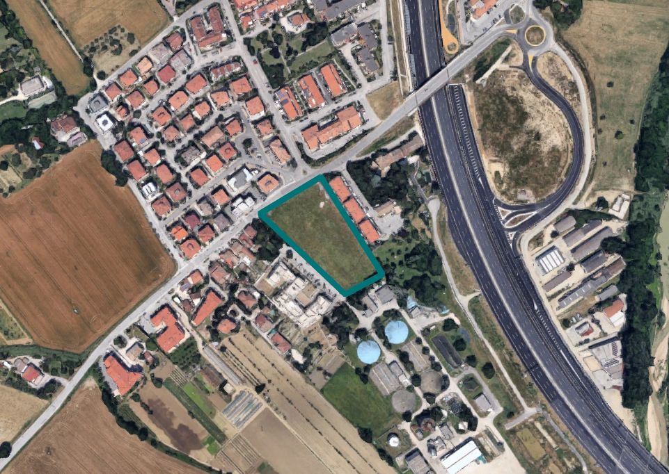
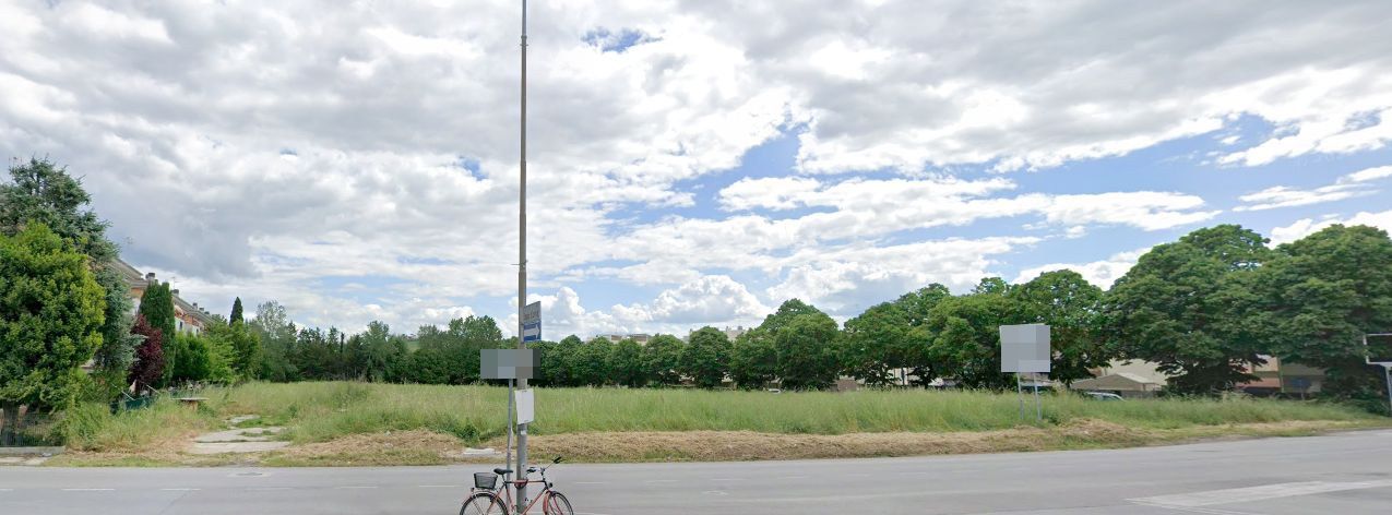
AT AUCTION Land in Senigallia (AN), Via Pò - LOT SE T001 - OFFER COLLECTION

The land up for auction is located in the western outlying area of the town of Senigallia, uphill from the A/14 motorway and near the motorway junction.
It has an area of 7,682 sqm.
The planning designation of the plot, according to the variant of Council Resolution no. 52 of 30-7-2019, is as follows:
sheet 27, parcel 1061 with a cadastral area of 7,659 sqm falls within:
- for m² 7,229, homogeneous territorial zone E - agricultural planning zone art. 19 of the N.T.A.;
- for m² 315, homogeneous territorial zone BR1 – completion planning zone art. 16 b, of the N.T.A.;
- for m² 115, homogeneous territorial zone BR3 – appurtenant areas and private courtyards art. 16 d, of the N.T.A.;

sheet 27, parcel 1067, cadastral m² 23, falls entirely within:
-- planning zone communication lines art. 13 of the N.T.A.

Please note that:
- parcel 1061 of sheet 27 falls within the basin excerpt plan for hydrogeological structure of the regional reference basins (PAI), as flood-prone areas at risk R3.
- For changes to the planning designation, safeguard rules of the PRG are in force, for part of parcel 1061 of sheet no. 27 falling in homogeneous zone B "BR3" and for appurtenant areas and private courtyards.

The tax regime of the sale will be determined within the limits of the regulations in force at the time of transfer and with reference to what is applied by the competent Financial Offices, without the receivership assuming any liability in this regard. Therefore, no account shall be taken in any way of any indications or references to the tax regime of the properties being auctioned reported in the appraisal reports and their attachments

Land Registry of the Municipality of Senigallia, Sheet 27:
Parcel 1061 - 1067

For further information, please consult the appraisal report and the documentation attached.

Retail surface: 7682 sqm

Lot Code: SE_T001

  • Attached documents (3)

 Offers:

Suspended Lot for

sold

Request more info Request viewing General Terms Specific Terms PVP data
ID Inserzione4589892
96085a28-6017-11f1-9859-0a586441166e
Procedura
Tipologiagiudiziaria
ID Procedura701528
Tipo Proceduragiudiziaria
ID Tribunale0440070095
ID RitoNFAL
ID RegistroPROCEDURE_CONCORSUALI
TribunaleTribunale di ASCOLI PICENO
RegistroPROCEDURE CONCORSUALI
RitoFALLIMENTARE (NUOVO RITO)
Num.Procedura43
Anno Procedura2019
Soggetti
  • Soggetto
    TipoSoggetto specializzato alla vendita
    Nome
    CognomeGobid international auction group srl
    Cod.Fisc.GRGNDR67A25H211F
    Email[email protected]
    Telefono0286882269
    ID Anagrafica5482206
    Soggetto Vendita1
    Soggetto Visita1
Lotto
ID Lotto2448066
Descrizione (IT)Terreno a Senigallia (AN - LOTTO SE_T001 - vendita telematica sulla piattaforma www.gobidreal.it n.31876.7
Primo Identificativo2448066
Codice7
GenereIMMOBILI
CategoriaALTRA CATEGORIA
IndirizzoVia Po'
ComuneSenigallia
ProvinciaAncona
RegioneMarche
NazioneItalia
Beni
  • Bene
    ID Bene3155595
    Descrizione (IT)IN ASTA Terreno a Senigallia (AN), Via Pò - LOTTO SE_T001 - RACCOLTA OFFERTE  Il terreno in asta è sito in zona periferica ovest dell’abitato di Senigallia a monte dell’autostrada A/14 ed in prossimit à dello svincolo autostradale Ha una superficie di 7.682 mq. La destinazione urbanist ica dell’appezzamento di terreno come da variante del cc. n. 52 del 30-7-2019, è la seguente foglio 27, part icella 1061 di catastali mq. 7659 ricade: - per m² 7.229, zona territoriale omogenea E - zona urbanistica agricola art . 19 delle N.T.A.; - per m² 315, zona territoriale omogenea BR1 – zona urban. di completamento art . 16 b, delle N.T.A.; - per m² 115, zona territoriale omogenea BR3 – aree pertinenziali e corti private art . 16 d, del le N.T.A.;  foglio 27, part icella 1067, di catastali m² 23, ricade interamente in: -- zona urbanist ica linee di comunicazione art . 13 delle N.T.A.  Si precisa che: - la particella 1061 del f. 27, ricade all’interno del piano stralcio di bacino per l’assetto idrogeologico dei bacini di ri lievo regionali (PAI) , come aree esondabili a rischio R3. - Per le modif iche alla dest inazione urbanist ica, sono in essere le norme di salvaguardia al PRG, per parte del la part . 1061 del Fg. n.27 ricadente in zona omogenea B “BR3” e per aree pertinenziali e cort i private.  Catasto Terreni del Comune di Senigallia al Foglio 27:  Particella 1061 - 1067  Per ulteriori informazioni consultare la perizia e la documentazione in allegato.
    Primo Identificativo3155595
    TipologiaALTRA CATEGORIA
    CategoriaTERRENO
    IndirizzoVia Po'
    ComuneSenigallia
    ProvinciaAncona
    RegioneMarche
    NazioneItalia
    Bene Immobile
    • Dati catastali
      Foglio/
      Particella/
    Tipo DenunciaProtocollo
Dati Vendita
Data e oraMon 20 July 2026 at 12:012026-07-20T12:01:00
TipologiaCOMPETITIVA
ModalitàPRESSO IL VENDITORE
Indirizzovendita telematica sulla piattaforma www.gobidreal.it
CAP20148
ComuneMilano
ProvinciaMilano
RegioneLombardia
NazioneItalia
Prezzo base37.968,75
Offerta Minima37.968,75
Rialzo Minimo1.000,00
Termine Presentazione OfferteMon 20 July 2026 at 12:002026-07-20T12:00:00
Siti
  • Sito
    ID22
    Tipologiasito pubblicita
    Nominativohttps://www.gobidreal.it/
    Indirizzo URLhttps://www.gobidreal.it/
Data pubblicazione04/06/20262026-06-04

Related lots

Need help?