 Italiano
 English
 Français
 Español
 Euskara
 Català
 Deutsch
 Nederlands
 Português
 Shqiptare
 Български
 Čeština
 Ελληνικά
 Hrvatski
 Magyar
 Македонски
 Polski
 Română
 Српски
 Slovenský
 Slovenščina
 Türkçe
 Русский
 Dansk
Dansk Suomalainen
 Íslenskur
 Norsk
Norsk Svenska
 Lombard
 Marchigiano
 Pugliese
 Romano
 Siciliano
 Toscano
 Veneto
-LOTTO-3_00002_thumb.jpg)
-LOTTO-3_00003_thumb.jpg)
-LOTTO-3_00004_thumb.jpg)
-LOTTO-3_00005_thumb.jpg)
-LOTTO-3_00006_thumb.jpg)
-LOTTO-3_00002_mid.jpg)
-LOTTO-3_00003_mid.jpg)
-LOTTO-3_00004_mid.jpg)
-LOTTO-3_00005_mid.jpg)
-LOTTO-3_00006_mid.jpg)
-LOTTO-3_00007_mid.jpg)
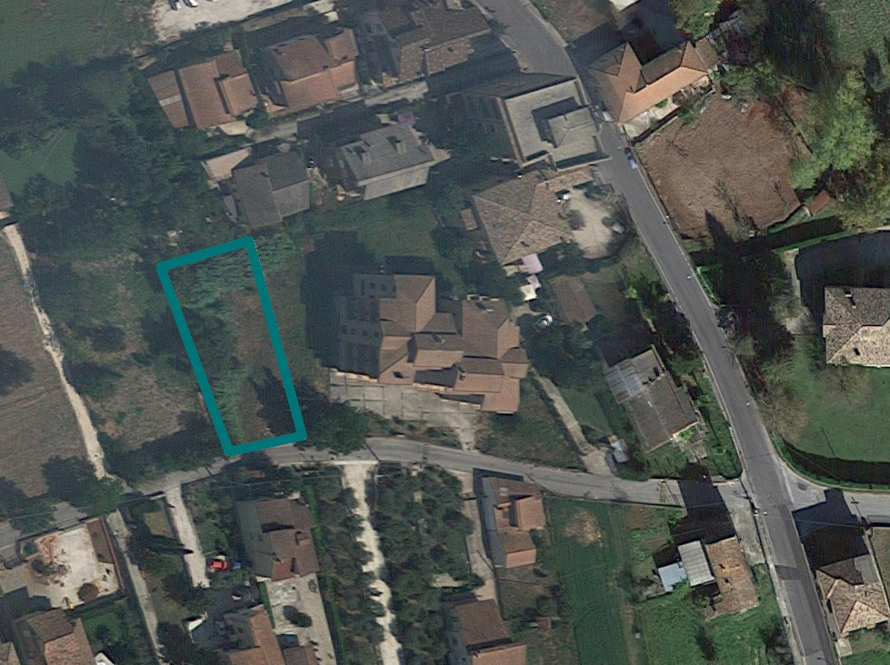
Lands in Isola del Liri (FR), Contrada Via Cupa - LOT 3
The lands are registered at Land Registry of City of Isola del Liri at sheet 13:
Parcel 467 - Quality Arable Land - Class 2 - Surface 420 sqm - R.D. € 3,69 - R.A. € 2,71
Parcel 478 - Quality Arable Land - Class 2 - Surface 575 sqm - R.D. € 5,05 - R.A. € 3,71
The lands in question have an almost regular shape and no slope. Currently it is uncultivated and covered by spontaneous vegetation.
The lands fall into the:
- PRG, in Zone "E1-Expansion of Inhabited Centers" area called "C" pursuant to DM 1444/1968;
- pursuant to the Perimetrazione del Centro Inhabited, prepared in accordance with the Highway Code and pursuant to the L.R. 59/95 maps within the area;
- pursuant to P.T.P.R. adopted with D.G.R. n. 1025 of 12/21/2007
- in the area "AGRICULTURAL LANDSCAPE OF VALUE" and in "RESPECT OF WATER COURSES" in accordance with table A32 - in the area "DIFFUSED PUNCTUAL ASSETS, 100mt RESPECTIVE RANGE" AND "PUBLIC WATER COURSES" pursuant to table B32;
- according to the excerpt plan for the hydro-geological structure-HYDRAULIC RISK BASIN LIRI-GARIGLIANO IN BAND "B".
For further information consult the appraisal (Good 5-6) and the attached documentation.
Area: 995 sqm